Geocaching is a version of a hide-and-seek game where the latitude/longitude coordinates are shared along with a hint to find what is hidden. It is a way to add fun to your hiking adventures. GPS devices come in handy for both activities. They not only provide precise positioning, but they also ensure you always know where you are with the preloaded maps. Some GPS devices for hiking can support Geocaching and are therefore very handy. Navigate your next outdoor adventures with such GPS devices and explore with confidence. Below are some of the best GPS devices for Geocaching and hiking available in the market.
What Are the Best GPS For Geocaching and Hiking?
| Photo | Title | Buy |
|---|---|---|

|
Best Handheld - Garmin GPSMAP 66st Multi-satellite Geocaching and Hunting GPS | Buy On Amazon.com |

|
Best with Sunlight-readable Display - Garmin eTrex 22x Handheld GPS Navigator | Buy On Amazon.com |

|
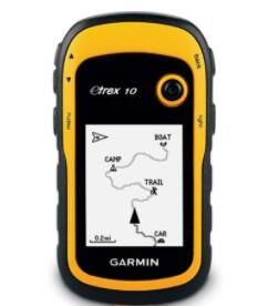
Best Durable - Garmin eTrex 10 Worldwide Handheld GPS Navigator with Waterproof Performance | Buy On Amazon.com |

|
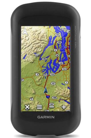
Best with High Sensitivity - Garmin Montana 680t Handheld GPS For Professional Geocaching | Buy On Amazon.com |

|
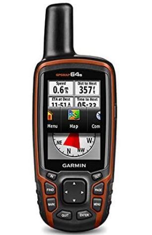
Best Smart - Garmin GPSMAP 64s Worldwide GPS For Geocaching and Hunting with Simple to Use Design | Buy On Amazon.com |
Benefits of Using GPS for Geocaching and Hiking
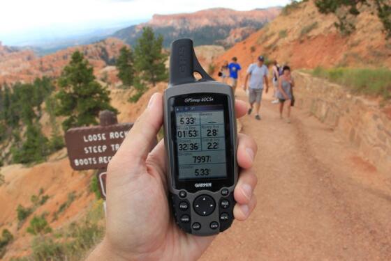
Handheld GPS receivers remain a valuable outdoor tool for hikers and other backcountry explorers. It provides information about where you are, where you have been, and where you want to go. They are indeed very beneficial.
Allows you to get close to nature
Using a GPS is exactly what you need to get back into nature. You do not have to walk with your nose glued to your compass or map. With this trusty and reliable device, it will guide you through and allow you to focus on nature’s beauty.
Make it hard to get lost.
Having a good GPS during hiking or Geocaching will make it unlikely to get lost. The GPS signal helps you always to find your way. With that knowledge, it will be simple getting back to where you need to be.
Document your explorations for future use
With a GPS device, you can easily document your new trails and store them in a memory bank, so you can decide to hit the same trail again. You can also share your discoveries with loved ones and friends.
Can be life-saving devices
You could encounter some problems and dangers while hiking. Many of the GPS units have an SOS button that you can use to send an emergency signal, and in no time, people will come to your aid.
Additional benefits
With the right brand and model of GPS, you can enjoy additional benefits. Some serve as navigation devices that help you arrive at your starting point.
Best GPS For Geocaching and Hiking Reviews
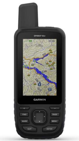
1. Best Handheld – Garmin GPSMAP 66st Multi-satellite Geocaching and Hiking GPS
Features:
- Garmin explore compatibility
- Altimeter, compass, and barometer
- Expanded wireless compatibility
- BirdsEye satellite imagery
- Multi-GNSS support
- Preloaded maps
- LED flashlight
Plan your next trip with the Garmin Multi-satellite handheld GPS. This GPS features a 3-inch color display that is easy to view. Also, it features access to Birdseye satellite imagery subscription with direct-to-device downloads that enable you always to find your way. It is ideal for hiking, Geocaching, mountain biking, or hunting. This premium GPS has a rugged build that makes it well suited for the harsh outdoor conditions. Moreover, it comes preloaded with Canada and TOPO U.S. maps.
This GPS enables wireless connectivity for direct downloads, Garmin Explore compatibility, and Active Weather. Furthermore, this GPS offers multi-GNSS support so you can easily track your travels in more challenging environments than GPS alone with the barometric altimeter and three-axis compass. You can use this GPS to get up-to-date forecasts, Geocaching lives, and animated weather radar for mobile syncing and updates. The Garmin Explore compatibility enables you to manage your tracks, waypoints, routes and review the field’s statistics. This GPS boasts of long 16-hour battery life and has an integrated LED flashlight for increased visibility.
Pros:
- This GPS comes preloaded with maps so you can know where you are
- It enables wireless connectivity so you can stay tuned to the weather conditions.
- The LED flashlight enhances visibility in low light conditions.
- The color display is easy to view, even in sunlight.
- The battery has a long life of up to 16 hours.
Cons:
- No voice notifications to ensure you are going in the right direction
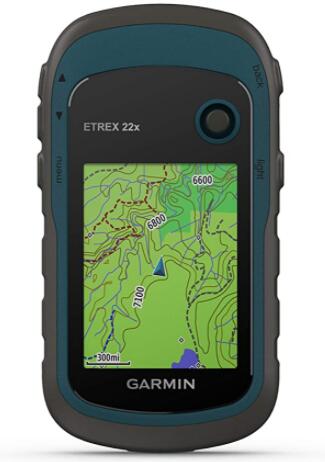
2. Best with Sunlight-readable Display – Garmin eTrex 22x Handheld GPS Navigator
Features:
- BirdsEye satellite imagery
- 2.2″ sunlight-readable color display
- GPS and GLONASS satellite systems
- Preloaded topoActive maps
- 8GB internal memory
- Two batteries
Navigate your outdoor adventure with the Garmin eTrex handheld GPS navigator. This navigator features an enhanced 65K, 2.2-inch color display that you can easily read in the sunlight. Moreover, it has a rugged build, durable, and water-resistant to withstand any element. This GPS comes preloaded with multiple TopoActive maps so you can always know where you are. Moreover, this reliable handheld GPS enables you to explore ATVs, bicycles, hiking, or boats confidently.
On top of that, this navigator supports the GPS and GLONASS systems that allow you to track your location in more challenging environments. It comes with a sizeable 8gb memory as well as a micro S.D. card slot so you can store your map downloads. This GPS is powered by two batteries that have a long life of up to 25 hours. Furthermore, this navigator supports paperless Geocaching for more fun in your adventures. This GPS supports the BirdsEye satellite imagery that requires a subscription to download and integrate the imagery with your maps.
Pros:
- The batteries have a long life.
- It has a large memory for all the downloaded maps.
- This navigator supports the GPS and GLONASS satellite systems for aid in the more challenging areas.
- It comes preloaded with TopoActive maps with routable roads and trails for cycling and hiking.
- It has a rugged build, water-resistant, and durable for the outdoors.
Cons:
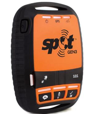
3. Best Compact – Spot 3 Satellite GPS Messenger with S.O.S System for Geocaching and Hiking
Features:
- Custom message
- Help/spot S. O. V
- Rugged design
- S. O. S system inserted
Spot 3 Satellite GPS Messenger is your ideal hiking and geocaching companion. This navigator is well designed to give you a critical and life-saving line of communication when you are traveling beyond the boundaries of cell service. This GPS incorporates the latest technology to ensure you always know where you are going and keeps your friends and family. In case of any problem, it sends your GPS location to emergency responders- all at the push of a button.
Besides that, this GPS messenger is pocket-sized for user-friendliness with a rigged design to withstand outdoor use rigors. This messenger is designed to send a programmed message with your GPS location to your contacts. Also, it allows you to send and save your location automatically. You can also request help from professional assistant organizations or your friends and family. This messenger is an essential gear for all your outdoor adventures, including hiking, Geocaching, cycling, hunting, and so on.
Pros:
- It offers a life-saving line of communication when you are out of cell service.
- It keeps your family and friends in the know of your location.
- You can request help from family, friends, or professional organizations.
- This messenger has a rugged design for outdoor use.
Cons:
4. Best Durable – Garmin eTrex 10 Worldwide Handheld GPS Navigator with Waterproof Performance
Features:
- High-sensitivity GPS receiver
- 2.2-inch monochrome display
- Garmin Connect compatible
- Worldwide base map
- Rugged build
Add the Garmin eTrex 10 Worldwide handheld GPS Navigator to your essential gear for hiking and Geocaching. This device, as the most dependable GPS available given its core functionality, affordability, and rugged construction. It is, therefore, well suited to withstand the harsh outdoor conditions. Moreover, it makes use of two batteries with a decent battery life of 25 hours. This navigator comes with a worldwide base map so you can take charge of your adventure. It is designed with a 2.2″ monochrome display that helps you view in any light.
What’s more is, this navigator supports the GPS and GLONASS satellite systems for faster positioning. It also supports paperless Geocaching, so you add fun to your adventure. The WAAS-enabled GPS receiver is highly sensitive, and with the HotFix satellite prediction, you will always locate your position precisely even in deep canyons or heavy cover. You can create Garmin Adventures to share with friends and family with the free trip-planning software. When paired with the BirdsEye satellite imagery subscription, you can transfer an unlimited amount of satellite images to your device. It comes with a barometric altimeter and an electronic compass for added functionality.
Pros:
- This device comes preloaded with a worldwide base map.
- The 2.2-inch monochrome display allows readability in any light.
- The GPS receiver is highly sensitive for fast positioning and a reliable signal.
- It is waterproof to IPX7 standards for protection against splashes and rain.
- It supports paperless Geocaching and Garmin spine mounting accessories.
Cons:
5. Best with High Sensitivity – Garmin Montana 680t Handheld GPS For Professional Geocaching
Features:
- 8MP camera
- Track manager
- GPS and GLONASS
- Preloaded geocaches
- BirdsEye Satellite imagery subscription
- 4-inch touchscreen display
The Garmin Montana 680t handheld GPS makes an excellent choice in handheld navigation for the outdoor enthusiast. This device features a dual-orientation and color touchscreen that is glove-friendly. It comes preloaded with TOPO U.S. 100K maps as well as the BirdsEye satellite imagery subscription for more downloadable maps. Moreover, it comes with a digital camera that provides excellent resolution, high-quality images, and automatically geotags the photos with coordinates. This handheld device comes with a barometric altimeter, a three-axis tilt-compensated compass, and access to the GPS and GLONASS satellite systems for faster fixes and improved positioning.
Additionally, this device supports paperless geocaching GPX files so you can upload the caches straight to the device. The track manager feature comes in handy to help organize and navigate routes, waypoints, and tracklogs. Furthermore, this device has a high-sensitivity WAAS-enabled receiver and a HotFix satellite prediction for precise positioning even in deep woods. The screen is sunlight-readable and easy to use. This GPS is battery-powered with long battery life.
Pros:
- This device supports paperless Geocaching.
- The screen is a sunlight-readable and easy-to-use touchscreen.
- The GPS receiver is highly sensitive to ensure precise and fast positioning.
- The camera enables high-quality and excellent resolution images.
- This GPS comes preloaded with TOPO U.S. maps.
Cons:
5. Best Smart – Garmin GPSMAP 64s Worldwide GPS For Geocaching and Hiking with Simple to Use Design
Features:
- 2.6-inch sunlight-readable color screen
- High-sensitivity GPS and GLONASS receiver
- Barometric altimeter and 3-axis compass
- BirdsEye Satellite imagery subscription
- 4GB internal memory
- Wireless connectivity
Garmin GPSMAP 64s worldwide is a perfect GPS device. This high-performance device is sleek yet rugged to make it well suited for the outdoors. It comes with a 2.6-inch sunlight-readable color screen for easy view. This device also has a high-sensitivity GPS and GLONASS receiver completer with a quad-helix antenna to offer superior connection. Moreover, this device comes with a three-axis electronic compass and a barometric altimeter. It offers a 1-year subscription to the BirdsEye satellite imagery and enables wireless connectivity.
On top of that, this GPS comes with a 4GB internal memory as well as a micro S.D. card slot for storing your maps. It supports paperless Geocaching with over 250,000 preloaded caches from Geocaching.com. It also comes with a built-in worldwide base map with shaded relief so you can easily navigate anywhere. The photo navigation enables you to download geotagged pictures from the internet.
Pros:
- It has a sleek and rugged design.
- It provides superior reception with a highly sensitive receiver.
- The large screen is easy to view and read in any light.
- It offers larger storage for your downloaded maps.
- It enables wireless connectivity.
Cons:
How to Choose the Best Gps for Geocaching and Hiking?
Choosing a GPS for Geocaching and hiking may not be as easy as it seems. There are some factors to be considered when choosing your handheld units for outdoors. Remember that a dedicated GPS unit should offer the following key advantages; a much more rugged and water resistance, field-replaceable batteries, superior satellite reception in remote areas, and robust features explicitly developed for outdoors. Below is the list of factors you need to be mindful of.
Size of unit vs. size of the screen
The size and weight of the unit will increase with the size of the screen. You are therefore required to decide on a large-screen and low-weight spectrum.
Interface preference
Some devices feature a touchscreen, and if this is what you are going for, you can narrow down your choices. However, for winter activities, look for one with button controls as they are easier to use with gloves.
Advanced features
The high-end units offer some advanced features like an electronic compass, barometer, and wireless transmission. If you find these capabilities crucial, they can help you narrow down your choices.
Geocaching features
Many of the units have geocaching functions that allow paperless Geocaching and manage your found caches.
Digital camera:
If you are interested in taking photos with your device, you can go for the digital camera units. They offer quality comparable to a primary phone camera. This function can also geotag photos so you can see on the map where you snapped each shot.
Memory:
The more memory you have, the more map and navigation data you can store. Additionally, most units allow you to expand your memory with a micro S.D. card.
Tips on Using GPS for Geocaching and Hiking
Even the most precise GPS units have a wide range of features and settings. Since each unit’s operation varies, you need to familiarize yourself with the owners’ manual. But here are the essential functions of all GPS units.
Display position
The GPS will tell you where you are by displaying the coordinates. Also, it shows your position on the base map or topo map.
Record tracks
When you turn on the tracking, the GPS will automatically lay down digital bread crumps called the track points at regular intervals. You can use them later to replace your steps or evaluate the path traveled.
Navigate point-to-point
The GPS will direct you by giving you the distance and direction to a location/ waypoint. You can enter the coordinates of the waypoints at home to pre-map them. When you are in the field, you can set the device to mark a waypoint where you want to return to, like a campsite and trailhead.
Display trip data
This odometer-like function tells you the cumulative stats like how far you have come and how high you have climbed.
FAQ:
Can GPS for Geocaching Be Used for Hiking?
Searching for hidden treasure is another way for those interested in outdoor adventures, and hiking can use location. They make it easier than ever to enjoy your hiking and geocaching experiences. Yes, GPS devices for Geocaching can be used for hiking as well. These GPS devices are designed to support Geocaching, and some even come with preloaded caches. You need one of these and set it to automatically update all the caches from the Geocaching live, including the cache descriptions, hints, and logs. You can also use your compass app or GPS to note the longitude and latitude and mark your discovered geocaches on the map.
Conclusion
Plan your next geocaching or hiking adventures with one of these premium handheld devices. They are feature-rich and high-performing to ensure you always know where you are. Moreover, they offer additional conveniences such as pocket-sized design, and some come with additional features such as a flashlight. Take one of these essential gear to your next trip and explore with confidence.
| Photo | Title | Buy |
|---|---|---|

|
Best Handheld - Garmin GPSMAP 66st Multi-satellite Geocaching and Hunting GPS | Buy On Amazon.com |

|
Best with Sunlight-readable Display - Garmin eTrex 22x Handheld GPS Navigator | Buy On Amazon.com |

|
Best Durable - Garmin eTrex 10 Worldwide Handheld GPS Navigator with Waterproof Performance | Buy On Amazon.com |

|
Best with High Sensitivity - Garmin Montana 680t Handheld GPS For Professional Geocaching | Buy On Amazon.com |

|
Best Smart - Garmin GPSMAP 64s Worldwide GPS For Geocaching and Hunting with Simple to Use Design | Buy On Amazon.com |
